This document explains how to add, edit and delete your existing wfs-t post.

Admin 10.03.2020 Category : WEB GIS Education Documents

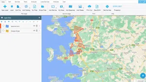
The WFS-T service sends a change (adding geometry, deleting geometry, and editing geometry) back to the WFS service to the source data, ensuring that the same change is present in the database. The WFS-T service can be published in the GisLayer software.

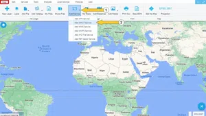
To publish WFS-T, click the 'Add WFS-T Service' button in the 'Add Service' drop-down list under the 'Data' tab.
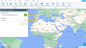
Adding WFS-T Service

Step 1: WFS-T Panel

The parameters in the WFS-T panel must be filled in correctly and completely. The panel is filled in step by step. The parameters to be entered in the first step are described below.

  1. Geoserver URL: Enter the URL address of the Geoserver is entered.
  2. Workspace: Enter the namespace to work in Geoserver.

NOTE: NOTE: Workspace section opens after entering the URL address.

Adding WFS-T Service

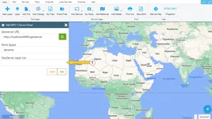
After the workspace is filled in, press the green button. If the result is successful Geoserver Layer List section opens. In this section, the layers in the GeoServer workspace are listed. The layer to be added to the map is selected.

Adding WFS-T Service

In the newly opened sections, the server version, the field name of the attribute table and, if desired, a query is entered.

Adding WFS-T Service

Adding WFS-T Service

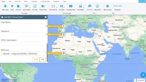
After the required parameters are filled in, the add button is pressed. The layer is added to the map.

Adding WFS-T Service

Step 2: Send a Change with WFS-T

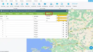
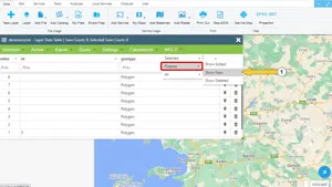
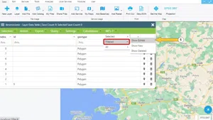
With the WFS-T service, changes made in layers added to the map (adding geometry, deleting geometry, editing geometry) can be sent to the server.

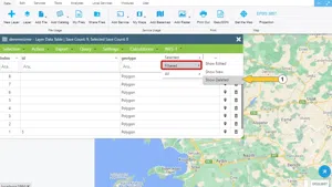
Layers added as WFS-T have an additional submenu called WFS-T in the attribute table. Using this submenu, changes made are sent to the server. There are 3 options in the submenu.

  1. Selected
  2. Filtered
  3. All

Adding WFS-T Service

  1. Send Added Geometries

This section describes how to send the newly added geometries back to the server.

New geometries added to the layer added as WFS-T can be sent to the server with 3 different options.

  1. Send newly added selected geometries
  2. Send newly added filtered geometries
  3. Send all newly added geometries

Adding WFS-T Service

  1. Send Edited Geometries

This section describes how to send the edited geometries back to the server.

Geometries edited on the layer added as WFS-T can be sent to the server with 3 different options.

  1. Send newly added selected geometries
  2. Send newly added filtered geometries
  3. Send all newly added geometries

Adding WFS-T Service

  1. Send Deleted Geometries

This section describes how to send the deleted geometries back to the server.

Geometries that existed before but were deleted on the layer added as WFS-T can be sent to the server with 3 different options

  1. Send newly added selected geometries
  2. Send newly added filtered geometries
  3. Send all newly added geometries

Adding WFS-T Service

Related Documents

Layer Box Usage

Layer Box Usage

10.03.2020
Adding WFS Service
Adding WMS Service

Other Documents

Create a New Vector Layer
Add Vector Layer Files
Layer Box Usage

3-Layer Box Usage

10.03.2020
Adding WFS Service
Adding WMS Service
Adding XYZ Tile Service
Adding PBF and MVT Vector Tile Service
Usage Basemaps & Adding to Map
Add Ministry Of Environment & Urbanisation Base Maps
Usage TKGM & HGM Basemaps
Vector Drawing On The Map
Drawing Special Geometric Shapes On The Map
Measuring Length & Area On The Map
Getting Information From Vector Feature On The Map
Selecting Vector Feature On The Map
Finding TKGM Parcels On The Map
Setting the Drawing Order of Layers
Adding Previously Used Layers
Displaying the Vector Layer Attribute Data Table
Selections In Attribute Table
Delete Records In Attribute Table
Showing Features Use By Data Attribute Table
Changing Features Color Use By Data Table
Export Attribute Table
Finding Country, City, District And Neighborhood Geometry
Downloading Open Street Map (OSM) Vector Data From The Map
Map Indexing System
Creating Buffers Around Geometries
Clipping Of Geometries Using Overlapping Geometries
Rotate Geometries Around a Specific Anchor
Moving Geometries From One Position To Another
Simplifying Geometries
Smoothing Geometries
Creating the Triangular Terrain Model Using Point Heights
Creating Point, Triangle, And Square Grids Within an Area
Downloading Maps For Offline Use
Get Points From Geometries and Layers
View GeoJson Format Of a Layer
View GeoTiff

39-View GeoTiff

10.03.2020
Add Data With Overpass API
Listing All Updates, Created & Deleted Features
Adding WFS-T Service
Changing Map Color
Raster Color Information
Saving & Displaying System Files
Listing System Files & Adding To The Map
Sharing System File
Displaying Files & People You Share
Displaying, Adding & Deleting My Shared Files
Adding the Shared File to The Map & Stop Sharing
Add, Edit, Delete Geometry in Real-Time
Sending Back System File Changes
Displaying Log Table
Making a Map Open to Everyone
Listing Maps Shared With Everyone
Drawing Arc

56-Drawing Arc

10.03.2020
Display Available GISMoney
Sign In

58-Sign In

10.03.2020
Adding Raster Files
Remote Sensing Analysis
Getting Printout Map
Spatial Layer Joining
Querying Layer Attributes
Layer Styling

64-Layer Styling

10.03.2020
Creating Analysis Result Chart
Heatmap Density Map Analysis
Thematic Map Analysis
Coordinate Transformation
Creating Isohips Curve
Catalogue Upload
Creating a Catalogue File
System Settings

72-System Settings

10.03.2020
Manual Free Hand Drawing
Google POI Data Collecting
Creating Elevation Profile
Downloading Layers as File
Finding Intersections Between Geometries