It teaches how to add and use base maps on the system.

Admin 10.03.2020 Category : WEB GIS Education Documents

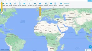
In GISLayer software, adding basemaps to the map is done by clicking the Add Basemaps button in the Data menu.

The location of the Add Basemaps button is shown in the screenshot below.

Usage Basemaps And Adding To Map

Part 1: Free Base Maps List Panel

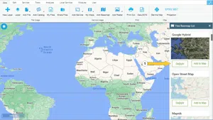
After clicking the Add Basemaps button, there is Free Basemap List on the panel opened on the right side of the screen. To add these basemaps to the map, click the Add to Map button.

The location of the Add to Map button is shown in the screenshot below.

Usage Basemaps And Adding To Map

After the above action, the Base Map is added to the Layer Box.

The following screenshot shows a free base map added image.

Usage Basemaps And Adding To Map

The base maps in the list are taken directly from the source and presented to the user without any changes. GISLayer Software does not charge any fees for using these resources.

Basemaps in the list

  1. Google Street View
  2. Google Terrain
  3. Google Hybrid
  4. Open Street Map
  5. Mapnik
  6. France
  7. HOT
  8. Topo
  9. Cycle Map
  10. Transport
  11. Transport Dark
  12. Landscape
  13. Outdoors
  14. Pionner
  15. Toner Background
  16. Toner Lite
  17. WaterColor
  18. Statemen Terrain
  19. Statemen Terrain BG
  20. ESRI World Street
  21. ESRI De Lorme
  22. ESRI Worl Topo
  23. ESRI Worl Imagery
  24. ESRI Worl Terrain
  25. ESRI Shaded Relief
  26. ESRI Physical
  27. ESRI Ocean
  28. ESRI Nat Geo
  29. ESRI World Gray
  30. CartoDB Positron
  31. CartoDB Dark
  32. CartoDB Voyager

Related Documents

Usage Basemaps & Adding to Map
Adding PBF and MVT Vector Tile Service
Adding XYZ Tile Service

Other Documents

Create a New Vector Layer
Add Vector Layer Files
Layer Box Usage

3-Layer Box Usage

10.03.2020
Adding WFS Service
Adding WMS Service
Adding XYZ Tile Service
Adding PBF and MVT Vector Tile Service
Usage Basemaps & Adding to Map
Add Ministry Of Environment & Urbanisation Base Maps
Usage TKGM & HGM Basemaps
Vector Drawing On The Map
Drawing Special Geometric Shapes On The Map
Measuring Length & Area On The Map
Getting Information From Vector Feature On The Map
Selecting Vector Feature On The Map
Finding TKGM Parcels On The Map
Setting the Drawing Order of Layers
Adding Previously Used Layers
Displaying the Vector Layer Attribute Data Table
Selections In Attribute Table
Delete Records In Attribute Table
Showing Features Use By Data Attribute Table
Changing Features Color Use By Data Table
Export Attribute Table
Finding Country, City, District And Neighborhood Geometry
Downloading Open Street Map (OSM) Vector Data From The Map
Map Indexing System
Creating Buffers Around Geometries
Clipping Of Geometries Using Overlapping Geometries
Rotate Geometries Around a Specific Anchor
Moving Geometries From One Position To Another
Simplifying Geometries
Smoothing Geometries
Creating the Triangular Terrain Model Using Point Heights
Creating Point, Triangle, And Square Grids Within an Area
Downloading Maps For Offline Use
Get Points From Geometries and Layers
View GeoJson Format Of a Layer
View GeoTiff

39-View GeoTiff

10.03.2020
Add Data With Overpass API
Listing All Updates, Created & Deleted Features
Adding WFS-T Service
Changing Map Color
Raster Color Information
Saving & Displaying System Files
Listing System Files & Adding To The Map
Sharing System File
Displaying Files & People You Share
Displaying, Adding & Deleting My Shared Files
Adding the Shared File to The Map & Stop Sharing
Add, Edit, Delete Geometry in Real-Time
Sending Back System File Changes
Displaying Log Table
Making a Map Open to Everyone
Listing Maps Shared With Everyone
Drawing Arc

56-Drawing Arc

10.03.2020
Display Available GISMoney
Sign In

58-Sign In

10.03.2020
Adding Raster Files
Remote Sensing Analysis
Getting Printout Map
Spatial Layer Joining
Querying Layer Attributes
Layer Styling

64-Layer Styling

10.03.2020
Creating Analysis Result Chart
Heatmap Density Map Analysis
Thematic Map Analysis
Coordinate Transformation
Creating Isohips Curve
Catalogue Upload
Creating a Catalogue File
System Settings

72-System Settings

10.03.2020
Manual Free Hand Drawing
Google POI Data Collecting
Creating Elevation Profile
Downloading Layers as File
Finding Intersections Between Geometries