This document teaches you how to create regular geometric shapes within an area you specify.

Admin 10.03.2020 Category : WEB GIS Education Documents

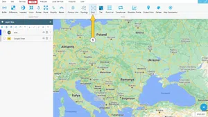
Step 1: Tools -> Grid

This tool is used to create identical geometries within a certain area. You can later use these geometries for many different purposes and move them to a different position on the map. Please follow the steps below to use the panel.

On the Tools menu, click the Grid button.

Creating Point, Triangle, And Square Grids Within An Area

Step 2: Grid Creation Panel

Creating Point, Triangle, And Square Grids Within An Area

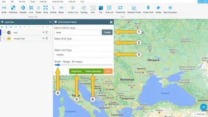
  1. Select the layer to which the grids are to be added.
  2. You can select grid type as point, square, triangle or hexagon.
  3. You can select the unit to be used for the distance between the grids.
  4. Set the distance between the grids.
  5. If there is no previously created area or previously created geometry, you can draw an area and create a grid within that area.
  6. If there is a previously created area, select a polygon from the map by clicking the button.

Note: You can easily create the layer with the quick layer creation button.

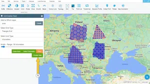
Once you select this, now that you have specified the area in which the grid is to be created, you can create new grids using the Create Grid button. You can see some of the grid examples created below. In addition, you can delete the polygon areas that you have used as boundaries by selecting the Delete Map option from the pop-up menu that opens with a right-click.

Creating Point, Triangle, And Square Grids Within An Area

Related Documents

Creating the Triangular Terrain Model Using Point Heights
Create a New Vector Layer

Other Documents

Create a New Vector Layer
Add Vector Layer Files
Layer Box Usage

3-Layer Box Usage

10.03.2020
Adding WFS Service
Adding WMS Service
Adding XYZ Tile Service
Adding PBF and MVT Vector Tile Service
Usage Basemaps & Adding to Map
Add Ministry Of Environment & Urbanisation Base Maps
Usage TKGM & HGM Basemaps
Vector Drawing On The Map
Drawing Special Geometric Shapes On The Map
Measuring Length & Area On The Map
Getting Information From Vector Feature On The Map
Selecting Vector Feature On The Map
Finding TKGM Parcels On The Map
Setting the Drawing Order of Layers
Adding Previously Used Layers
Displaying the Vector Layer Attribute Data Table
Selections In Attribute Table
Delete Records In Attribute Table
Showing Features Use By Data Attribute Table
Changing Features Color Use By Data Table
Export Attribute Table
Finding Country, City, District And Neighborhood Geometry
Downloading Open Street Map (OSM) Vector Data From The Map
Map Indexing System
Creating Buffers Around Geometries
Clipping Of Geometries Using Overlapping Geometries
Rotate Geometries Around a Specific Anchor
Moving Geometries From One Position To Another
Simplifying Geometries
Smoothing Geometries
Creating the Triangular Terrain Model Using Point Heights
Creating Point, Triangle, And Square Grids Within an Area
Downloading Maps For Offline Use
Get Points From Geometries and Layers
View GeoJson Format Of a Layer
View GeoTiff

39-View GeoTiff

10.03.2020
Add Data With Overpass API
Listing All Updates, Created & Deleted Features
Adding WFS-T Service
Changing Map Color
Raster Color Information
Saving & Displaying System Files
Listing System Files & Adding To The Map
Sharing System File
Displaying Files & People You Share
Displaying, Adding & Deleting My Shared Files
Adding the Shared File to The Map & Stop Sharing
Add, Edit, Delete Geometry in Real-Time
Sending Back System File Changes
Displaying Log Table
Making a Map Open to Everyone
Listing Maps Shared With Everyone
Drawing Arc

56-Drawing Arc

10.03.2020
Display Available GISMoney
Sign In

58-Sign In

10.03.2020
Adding Raster Files
Remote Sensing Analysis
Getting Printout Map
Spatial Layer Joining
Querying Layer Attributes
Layer Styling

64-Layer Styling

10.03.2020
Creating Analysis Result Chart
Heatmap Density Map Analysis
Thematic Map Analysis
Coordinate Transformation
Creating Isohips Curve
Catalogue Upload
Creating a Catalogue File
System Settings

72-System Settings

10.03.2020
Manual Free Hand Drawing
Google POI Data Collecting
Creating Elevation Profile
Downloading Layers as File
Finding Intersections Between Geometries