POI is the location of a specific point that a person might find useful or interesting. You can easily collect POI in GISLayer software. This document describes how to collect google POI.
You can easily collect POI points in the GISLayer software. In the process of collecting Google POIs on the map in GISLayer software, the user will need a vector layer to collect the POI points in one layer. If you don't have a layer
Data -> New Layer
you can create a new layer from the panel opened by clicking the button.
You can also take advantage of the fast layer creation feature with the create button in the panel.
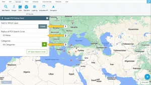
1 Google POI Finder Panel
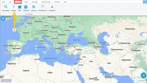
To access the Google POI menu, click on the "Google" button in the services menu.
Parameters to be entered in the Google POI find panel:
1.1.Which layer to add
2.2.POI radius of the search circle
3.Categories
These parameters must be filled in completely.
There are various options in the categories field. These;
- Accounting
- Administrative Area Level 1
- Administrative Area Level 2
- Administrative Area Level 3
- Administrative Area Level 4
- Administrative Area Level 5
- Airport
- Amusement Park
- Aquarium
- Archipelago
- Art Gallery
- Atm
- Bakery
- Bank
- Bar
- Beauty Salon
- Bicycle Store
- Book Store
- Bowling Alley
- Bus Station
- Cafe
- Campground
- Car Dealer
- Car Rental
- Car Repair
- Car Wash
- Casino
- Cemetery
- Church
- City Hall
- Clothing Store
- Colloquial Area
- Continent
- Convenience Store
- Country
- Courthouse
- Dentist
- Department Store
- Doctor
- Drugstore
- Electrician
- Electronics Store
- Embassy
- Establishment
- Finance
- Fire Station
- Floor
- Florist
- Food
- Funeral Home
- Furniture Store
- Gas Station
- General Contractor
- Geocode
- Gym
- Hair Care
- Hardware Store
- Health
- Hindu Temple
- Home Goods Store
- Hospital
- İnsurance Agency
- İntersection
- Jewelry Store
- Landmark
- Laundry
- Lawyer
- Library
- Light Rail Station
- Liquor Store
- Local Government Office
- Locality
- Locksmith
- Lodging
- Meal Delivery
- Meal Takeaway
- Mosque
- Movie Rental
- Movie Theater
- Movig Company
- Museum
- Natural Feature
- Neighborhood
- Night Club
- Painter
- Park
- Parking
- Pet Store
- Pharmacy
- Physiotherapist
- Place Of Worship
- Plumber
- Plus Code
- Point Of İnterest
- Police
- Political
- Post Box
- Post Office
- Postal Code
- Postal Code Prefix
- Postal Code Suffix
- Postal Town
- Premise
- Primary School
- Real Estate Agency
- Restaurant
- Roofing Contractor
- Room
- Route
- Rv Park
- School
- Secondary School
- Shoe Store
- Shopping Mall
- Spa
- Stadium
- Storage
- Store
- Street Address
- Street Number
- Sublocality
- Sublocality Level 1
- Sublocality Level 2
- Sublocality Level 3
- Sublocality Level 4
- Sublocality Level 5
- Subpremise
- Subway Station
- Supermarket
- Synagogue
- Taxi Stand
- Tourist Attraction
- Town Square
- Train Station
- Transit Station
- Travel Agency
- University
- Veterinary Care
- Zoo
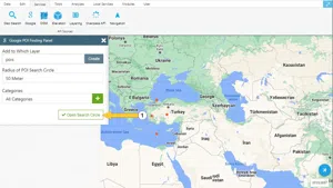
The required fields are filled and the "Open Search Circle" button is clicked. Then POI points are started to be collected.
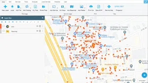
An example result is shown below.


Related Documents