Turkey WMS, which is submitted to the ministry of environment and urban users are taught how to use the litter WMTS.

Admin 10.03.2020 Category : WEB GIS Education Documents

Ministry of Environment and Urbanisation Base Maps cannot be used for commercial purposes.

After selecting the country in the local services menu, click on the GIS Basemaps button.

Add Ministry Of Environment And Urbanisation Base Maps

Part 1: Ministry of Environment and Urbanisation Base Maps List Panel

After you click on the Ministry of Environment and Urbanisation Base Maps button, a window opens on the right side of the screen with Ministry of Environment and Urbanisation Base Maps List.

Add Ministry Of Environment And Urbanisation Base Maps

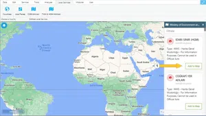
When we click the add to map button under the base maps, the layers to be added are selected in the panel that appears.

Add Ministry Of Environment And Urbanisation Base Maps

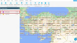
After the above action, the Base Map is added to the Layer Box.

The following screenshot shows a base map added image.

Add Ministry Of Environment And Urbanisation Base Maps

The base maps in the list are taken directly from the source and presented to the user without any changes. GISLayer Software does not charge any fees for using these resources.

List of Base Maps provided by the Ministry

  1. ADMINISTRATIVE BORDER (HGM)
  2. GEOGRAPHICAL PLACE NAMES
  3. GEOGRAPHIC GRID
  4. UTM GRID 25000
  5. UTM GRID 100000
  6. UTM ZONE
  7. SHEET LEGEND
  8. Antalya-Burdur-Isparta Environmental Plan
  9. Ardahan-Kars-Iğdır-Ağrı Environmental Plan
  10. Amasya Environmental Plan
  11. Aydın-Muğla-Denizli Environmental Plan
  12. Adıyaman-Şanlıurfa-Diyarbakır Environmental Plan
  13. Bilecik Environmental Plan
  14. Bartın Environmental Plan
  15. Bolu Environmental Plan
  16. Balıkesir-Çanakkale Environmental Plan
  17. Erzurum-Erzincan-Bayburt Environmental Plan
  18. Tekirdağ-Kırklareli-Edirne Environmental Plan
  19. İzmir-Manisa Environmental Plan
  20. Kilis Environmental Plan
  21. Kırıkkale Environmental Plan
  22. Konya-Karaman Environmental Plan
  23. Kırşehir-Nevşehir-Niğde-Aksaray Environmental Plan
  24. Mersin-Adana Environmental Plan
  25. Mardin-Batman-Siirt-Şırnak-Hakkari Environmental Plan
  26. Muş-Bitlis-Van Environmental Plan
  27. Malatya-Elazig-Bingöl-Tunceli Environmental Plan
  28. Osmaniye Environmental Plan
  29. Ordu-Trabzon-Rize-Giresun-Gümüşhane-Artvin Environmental Plan
  30. Samsun-Çorum-Tokat Environmental Plan
  31. Sinop Environmental Plan
  32. Yozgat-Sivas-Kayseri Environmental Plan
  33. Yalova Environmental Plan
  34. Sinop-Kastamonu-Çankırı Environmental Plan
  35. Zonguldak-Bartın-Karabük Environmental Plan
  36. Integrated Coastal Area Plan
  37. Integrated Coastal Area Plan
  38. Integrated Coastal Area Plan
  39. Integrated Coastal Area Plan
  40. UTM ZONE
  41. TUIK STATISTICS GRID
  42. AIR QUALITY GRIDS
  43. AIR MONITORING STATIONS
  44. EMEP GRID 1K
  45. EMEP GRID 50K
  46. GEOGRAPHIC GRID
  47. UTM GRID 25000
  48. UTM GRID 100000
  49. TUIK POPULATION 2013
  50. TUIK POPULATION 2014
  51. TUIK POPULATION 2015
  52. TUIK POPULATION 2018
  53. TUIK DISTRICT
  54. CORINE 1990
  55. CORINE 2000
  56. CORINE 2006
  57. CORINE 2012
  58. CORINE 2018
  59. GROUND MOTION STATIONS
  60. TRANSPORT
  61. SRTM
  62. RASAT
  63. EUROPE URBAN ATLAS
  64. İZMİR REAL ORTOPHOTO
  65. HGK ATLAS
  66. CBSGM CSV FILES

Related Documents

Usage Basemaps & Adding to Map
Adding PBF and MVT Vector Tile Service
Adding XYZ Tile Service
Adding WMS Service
Adding WFS Service

Other Documents

Create a New Vector Layer
Add Vector Layer Files
Layer Box Usage

3-Layer Box Usage

10.03.2020
Adding WFS Service
Adding WMS Service
Adding XYZ Tile Service
Adding PBF and MVT Vector Tile Service
Usage Basemaps & Adding to Map
Add Ministry Of Environment & Urbanisation Base Maps
Usage TKGM & HGM Basemaps
Vector Drawing On The Map
Drawing Special Geometric Shapes On The Map
Measuring Length & Area On The Map
Getting Information From Vector Feature On The Map
Selecting Vector Feature On The Map
Finding TKGM Parcels On The Map
Setting the Drawing Order of Layers
Adding Previously Used Layers
Displaying the Vector Layer Attribute Data Table
Selections In Attribute Table
Delete Records In Attribute Table
Showing Features Use By Data Attribute Table
Changing Features Color Use By Data Table
Export Attribute Table
Finding Country, City, District And Neighborhood Geometry
Downloading Open Street Map (OSM) Vector Data From The Map
Map Indexing System
Creating Buffers Around Geometries
Clipping Of Geometries Using Overlapping Geometries
Rotate Geometries Around a Specific Anchor
Moving Geometries From One Position To Another
Simplifying Geometries
Smoothing Geometries
Creating the Triangular Terrain Model Using Point Heights
Creating Point, Triangle, And Square Grids Within an Area
Downloading Maps For Offline Use
Get Points From Geometries and Layers
View GeoJson Format Of a Layer
View GeoTiff

39-View GeoTiff

10.03.2020
Add Data With Overpass API
Listing All Updates, Created & Deleted Features
Adding WFS-T Service
Changing Map Color
Raster Color Information
Saving & Displaying System Files
Listing System Files & Adding To The Map
Sharing System File
Displaying Files & People You Share
Displaying, Adding & Deleting My Shared Files
Adding the Shared File to The Map & Stop Sharing
Add, Edit, Delete Geometry in Real-Time
Sending Back System File Changes
Displaying Log Table
Making a Map Open to Everyone
Listing Maps Shared With Everyone
Drawing Arc

56-Drawing Arc

10.03.2020
Display Available GISMoney
Sign In

58-Sign In

10.03.2020
Adding Raster Files
Remote Sensing Analysis
Getting Printout Map
Spatial Layer Joining
Querying Layer Attributes
Layer Styling

64-Layer Styling

10.03.2020
Creating Analysis Result Chart
Heatmap Density Map Analysis
Thematic Map Analysis
Coordinate Transformation
Creating Isohips Curve
Catalogue Upload
Creating a Catalogue File
System Settings

72-System Settings

10.03.2020
Manual Free Hand Drawing
Google POI Data Collecting
Creating Elevation Profile
Downloading Layers as File
Finding Intersections Between Geometries