Changes made in the system file are recorded in the log file. The changes made in the log file are displayed and it can be seen who made it. Also, the transactions made can be undone.

Admin 10.03.2020 Category : WEB GIS Education Documents

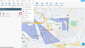
Changes made in system files are saved in the log file. Thanks to the log information, the changes made can be observed or even undone. In order to view the log information, click on the ‘Display Log File' button, one of the options of the layer whose log information is to be accessed, in the layer box.

Displaying Log File

Step 1: Log File

Displaying Log File

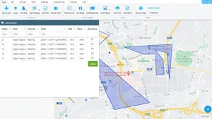
The changes made in the file are listed in the log file. When the change was made and by whom, can be seen. In addition, the old versions of the edited geometries can be displayed.

Displaying Log File

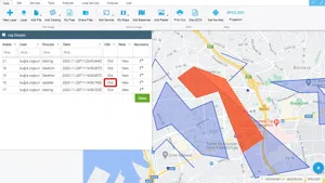
Deleted geometries can be displayed.

Displaying Log File

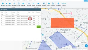
With the Recycle button, geometries are restored to their previous state so data loss is prevented.

Related Documents

Other Documents

Create a New Vector Layer
Add Vector Layer Files
Layer Box Usage

3-Layer Box Usage

10.03.2020
Adding WFS Service
Adding WMS Service
Adding XYZ Tile Service
Adding PBF and MVT Vector Tile Service
Usage Basemaps & Adding to Map
Add Ministry Of Environment & Urbanisation Base Maps
Usage TKGM & HGM Basemaps
Vector Drawing On The Map
Drawing Special Geometric Shapes On The Map
Measuring Length & Area On The Map
Getting Information From Vector Feature On The Map
Selecting Vector Feature On The Map
Finding TKGM Parcels On The Map
Setting the Drawing Order of Layers
Adding Previously Used Layers
Displaying the Vector Layer Attribute Data Table
Selections In Attribute Table
Delete Records In Attribute Table
Showing Features Use By Data Attribute Table
Changing Features Color Use By Data Table
Export Attribute Table
Finding Country, City, District And Neighborhood Geometry
Downloading Open Street Map (OSM) Vector Data From The Map
Map Indexing System
Creating Buffers Around Geometries
Clipping Of Geometries Using Overlapping Geometries
Rotate Geometries Around a Specific Anchor
Moving Geometries From One Position To Another
Simplifying Geometries
Smoothing Geometries
Creating the Triangular Terrain Model Using Point Heights
Creating Point, Triangle, And Square Grids Within an Area
Downloading Maps For Offline Use
Get Points From Geometries and Layers
View GeoJson Format Of a Layer
View GeoTiff

39-View GeoTiff

10.03.2020
Add Data With Overpass API
Listing All Updates, Created & Deleted Features
Adding WFS-T Service
Changing Map Color
Raster Color Information
Saving & Displaying System Files
Listing System Files & Adding To The Map
Sharing System File
Displaying Files & People You Share
Displaying, Adding & Deleting My Shared Files
Adding the Shared File to The Map & Stop Sharing
Add, Edit, Delete Geometry in Real-Time
Sending Back System File Changes
Displaying Log Table
Making a Map Open to Everyone
Listing Maps Shared With Everyone
Drawing Arc

56-Drawing Arc

10.03.2020
Display Available GISMoney
Sign In

58-Sign In

10.03.2020
Adding Raster Files
Remote Sensing Analysis
Getting Printout Map
Spatial Layer Joining
Querying Layer Attributes
Layer Styling

64-Layer Styling

10.03.2020
Creating Analysis Result Chart
Heatmap Density Map Analysis
Thematic Map Analysis
Coordinate Transformation
Creating Isohips Curve
Catalogue Upload
Creating a Catalogue File
System Settings

72-System Settings

10.03.2020
Manual Free Hand Drawing
Google POI Data Collecting
Creating Elevation Profile
Downloading Layers as File
Finding Intersections Between Geometries