This document teaches you how to find map sheets of a certain scale that are systematically divided.

Admin 10.03.2020 Category : WEB GIS Education Documents

The user needs to create a layer to continue this process. To create a new layer click the New Layer button under the Data menu.
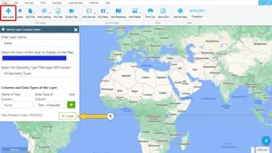
Map Indexing System

Note: You can easily create the layer with the quick layer creation button.

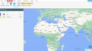
Step 1: Services -> Map Indexes

After creating a layer, go to the Services menu and click the Map Indexes button.

Map Indexing System

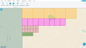
When mapping an area, it may not be possible to draw in one sheet, depending on the scale. Therefore the area should be divided into sections with some rules. The process of dividing the area into sections using the differences in latitude and longitude calculated in accordance with the scale is known as indexing.

Step 2: Indexing Service

Map Indexing System

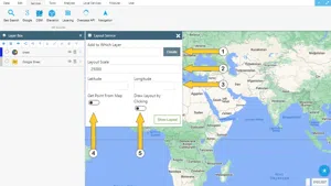
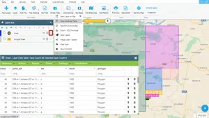
  1. First, in the window of the Indexing Service opened on the screen, you should choose on which layer the map indexes should be saved.
  2. The scale of the map indexes to be created should be determined according to the requirements of use.
  3. Latitude and longitude to find out on which map sheet a particular point is located, the user must enter the coordinates of the point. If the coordinates are unknown, leave this section blank.
  4. If you want to find out on which map sheet is a point whose approximate location is known, the option Take a point from the map should be activated.
  5. When the Draw Map Index by Click option is enabled, the map sheet boundaries covering a selected point will be displayed on the map.

Map Indexing System

Map Indexing System

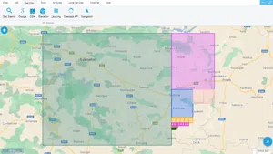
Created indexes can be displayed as a list in the Layer Attribute Table.

Map Indexing System

Related Documents

Create a New Vector Layer
Layer Box Usage

Layer Box Usage

10.03.2020

Other Documents

Create a New Vector Layer
Add Vector Layer Files
Layer Box Usage

3-Layer Box Usage

10.03.2020
Adding WFS Service
Adding WMS Service
Adding XYZ Tile Service
Adding PBF and MVT Vector Tile Service
Usage Basemaps & Adding to Map
Add Ministry Of Environment & Urbanisation Base Maps
Usage TKGM & HGM Basemaps
Vector Drawing On The Map
Drawing Special Geometric Shapes On The Map
Measuring Length & Area On The Map
Getting Information From Vector Feature On The Map
Selecting Vector Feature On The Map
Finding TKGM Parcels On The Map
Setting the Drawing Order of Layers
Adding Previously Used Layers
Displaying the Vector Layer Attribute Data Table
Selections In Attribute Table
Delete Records In Attribute Table
Showing Features Use By Data Attribute Table
Changing Features Color Use By Data Table
Export Attribute Table
Finding Country, City, District And Neighborhood Geometry
Downloading Open Street Map (OSM) Vector Data From The Map
Map Indexing System
Creating Buffers Around Geometries
Clipping Of Geometries Using Overlapping Geometries
Rotate Geometries Around a Specific Anchor
Moving Geometries From One Position To Another
Simplifying Geometries
Smoothing Geometries
Creating the Triangular Terrain Model Using Point Heights
Creating Point, Triangle, And Square Grids Within an Area
Downloading Maps For Offline Use
Get Points From Geometries and Layers
View GeoJson Format Of a Layer
View GeoTiff

39-View GeoTiff

10.03.2020
Add Data With Overpass API
Listing All Updates, Created & Deleted Features
Adding WFS-T Service
Changing Map Color
Raster Color Information
Saving & Displaying System Files
Listing System Files & Adding To The Map
Sharing System File
Displaying Files & People You Share
Displaying, Adding & Deleting My Shared Files
Adding the Shared File to The Map & Stop Sharing
Add, Edit, Delete Geometry in Real-Time
Sending Back System File Changes
Displaying Log Table
Making a Map Open to Everyone
Listing Maps Shared With Everyone
Drawing Arc

56-Drawing Arc

10.03.2020
Display Available GISMoney
Sign In

58-Sign In

10.03.2020
Adding Raster Files
Remote Sensing Analysis
Getting Printout Map
Spatial Layer Joining
Querying Layer Attributes
Layer Styling

64-Layer Styling

10.03.2020
Creating Analysis Result Chart
Heatmap Density Map Analysis
Thematic Map Analysis
Coordinate Transformation
Creating Isohips Curve
Catalogue Upload
Creating a Catalogue File
System Settings

72-System Settings

10.03.2020
Manual Free Hand Drawing
Google POI Data Collecting
Creating Elevation Profile
Downloading Layers as File
Finding Intersections Between Geometries