This document teaches you how to create the buffer buffer area to existing geometries.

Admin 10.03.2020 Category : WEB GIS Education Documents

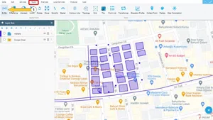
Buffering is a process to analyze a single geometry or all geometries in an area according to a certain distance around them. In other words, it is used to analyze the proximity of geometry as a function of a certain distance.

Step 1: Tools -> Buffer>

After selecting the Tools menu click the Buffer button.

Creating Buffers Around Geometries

Step 2: Buffer Panel

This step can be performed in two different ways depending on the use of geometry.

2.1 Choose a Geometry

Creating Buffers Around Geometries

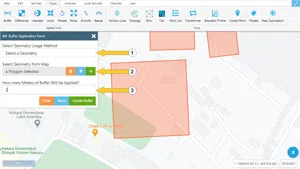
  1. When geometry is used, the user can create a buffer for only one selected geometry. To create a buffer for all geometries please see title 2.2.
  2. To select the geometry from the map for which the Buffer will be created, the user must first press the green button and select a geometry on the map.
  3. The distance in meters should be typed for the buffer area around the geometry

2.2 Choose a Layer

Creating Buffers Around Geometries

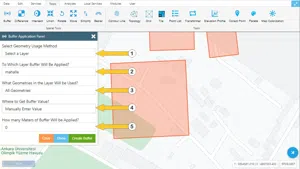
  1. Please select the Geometry Usage Method as Choose a Layer.
  2. The layer that will be used to create the buffer and that contains the geometries should be selected.
  3. If one of the fields of the attribute table of the layer to be used to create the buffer contains information, the corresponding field should be selected<. If there is no information, leave this section blank.
  4. If you want to create a buffer around more than one geometry in the layer, select “All Selected Geometries”; if you want to create a buffer around all geometries in the layer, select “All Geometries”, one of the two options must be selected.
  5. The distance in meters should be typed for the buffer area around the geometry

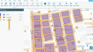
The newly created layer is added to the Layer Box when the above actions are performed.

Creating Buffers Around Geometries

Related Documents

Create a New Vector Layer
Add Vector Layer Files

Other Documents

Create a New Vector Layer
Add Vector Layer Files
Layer Box Usage

3-Layer Box Usage

10.03.2020
Adding WFS Service
Adding WMS Service
Adding XYZ Tile Service
Adding PBF and MVT Vector Tile Service
Usage Basemaps & Adding to Map
Add Ministry Of Environment & Urbanisation Base Maps
Usage TKGM & HGM Basemaps
Vector Drawing On The Map
Drawing Special Geometric Shapes On The Map
Measuring Length & Area On The Map
Getting Information From Vector Feature On The Map
Selecting Vector Feature On The Map
Finding TKGM Parcels On The Map
Setting the Drawing Order of Layers
Adding Previously Used Layers
Displaying the Vector Layer Attribute Data Table
Selections In Attribute Table
Delete Records In Attribute Table
Showing Features Use By Data Attribute Table
Changing Features Color Use By Data Table
Export Attribute Table
Finding Country, City, District And Neighborhood Geometry
Downloading Open Street Map (OSM) Vector Data From The Map
Map Indexing System
Creating Buffers Around Geometries
Clipping Of Geometries Using Overlapping Geometries
Rotate Geometries Around a Specific Anchor
Moving Geometries From One Position To Another
Simplifying Geometries
Smoothing Geometries
Creating the Triangular Terrain Model Using Point Heights
Creating Point, Triangle, And Square Grids Within an Area
Downloading Maps For Offline Use
Get Points From Geometries and Layers
View GeoJson Format Of a Layer
View GeoTiff

39-View GeoTiff

10.03.2020
Add Data With Overpass API
Listing All Updates, Created & Deleted Features
Adding WFS-T Service
Changing Map Color
Raster Color Information
Saving & Displaying System Files
Listing System Files & Adding To The Map
Sharing System File
Displaying Files & People You Share
Displaying, Adding & Deleting My Shared Files
Adding the Shared File to The Map & Stop Sharing
Add, Edit, Delete Geometry in Real-Time
Sending Back System File Changes
Displaying Log Table
Making a Map Open to Everyone
Listing Maps Shared With Everyone
Drawing Arc

56-Drawing Arc

10.03.2020
Display Available GISMoney
Sign In

58-Sign In

10.03.2020
Adding Raster Files
Remote Sensing Analysis
Getting Printout Map
Spatial Layer Joining
Querying Layer Attributes
Layer Styling

64-Layer Styling

10.03.2020
Creating Analysis Result Chart
Heatmap Density Map Analysis
Thematic Map Analysis
Coordinate Transformation
Creating Isohips Curve
Catalogue Upload
Creating a Catalogue File
System Settings

72-System Settings

10.03.2020
Manual Free Hand Drawing
Google POI Data Collecting
Creating Elevation Profile
Downloading Layers as File
Finding Intersections Between Geometries