This document teaches BlueGIS users how to make verbal and spatial queries using the attribute table.

Admin 10.03.2020 Category : BlueGIS Mobile Education Documents

In the BlueGIS software, various queries can be performed on the layer data in the operation menu under the layer attribute table. To access the queries, click on the Queries button in the Operations menu after opening the layer attribute table menü.

Attribute Table - Text Queries And Spatial Queries

Step 1: Attribute Table Operations

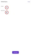
There are two types of queries.

  • Attribute Queries
  • Spatial Queries
  1. Attribute Queries

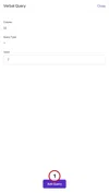
Click on Attribute Queries option in the Queries menu.

Attribute Table - Text Queries And Spatial Queries

In the Attribute query panel, select the column that you want to query and select the query type.

Attribute Table - Text Queries And Spatial Queries

After making the selection, the value box opens according to the option selected below. Write the value in the box that drop-down and click the 'Add Query' button.

Attribute Table - Text Queries And Spatial Queries

Add as many queries as desired. But do not forget that queries work together. To run the queries added to the list click the Query button.

Attribute Table - Text Queries And Spatial Queries

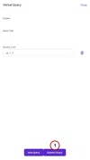
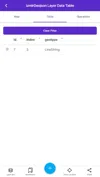
The result of the query is shown in the attribute table.

Attribute Table - Text Queries And Spatial Queries

  1. Spatial Queries

Click on the 'Spatial Queries' option in the Queries menu.

Attribute Table - Text Queries And Spatial Queries

Select the query. Various queries are available. Query list:

  • Length
  • Area
  • Find intersection geometries
  • Find the geometries that are in it
  • Find what's in the geometry
  • Find overlapping geometries
  • Find non-intersecting geometries

There may be different input parameters depending on the query selected. Here, the area query is selected as an example.

Attribute Table - Text Queries And Spatial Queries

The query is run with the Apply button and the results are displayed in the attribute table.

Attribute Table - Text Queries And Spatial Queries

Related Documents

Attribute Table and Features

Other Documents

Creating Vector Layer
Spatial Data Uploading
Upload Multiple Spatial Files
Layer Box Usage

4-Layer Box Usage

10.03.2020
Attribute Table and Features
Feature Attribute Table - Operations
Attribute Table - Text Queries And Spatial Queries
Drawing New Feature
Downloading Layer
Labels

10-Labels

10.03.2020
Z-index Replacement
Adding WFS Service
Adding WMS Service
Adding WMTS Service
Adding WFS-T Service
Adding XYZ Services
Adding PBF Service
Add Vector Tile

18-Add Vector Tile

10.03.2020
Adding Street Basemap
Adding Satellite Basemap
Adding Special Basemaps
Add Catalog

22-Add Catalog

10.03.2020
Create A Catalog File
List Catalogs

24-List Catalogs

10.03.2020
Re-Adding Previously Added Layers
Filtering With Overpass API
Creating Elevation Profile
Coordinate Tracking
Navigation

29-Navigation

10.03.2020
Application

30-Application

10.03.2020
Length Measurement
Area Measurement
Coordinate Conversion
Point Creation Using Slope And Distance
Bearing And Length Calculation
Bookmarks

36-Bookmarks

10.03.2020
Printing Out The Map
Changing The Language
Night Mode

39-Night Mode

10.03.2020
Changing Basemap
Creating Point By Clicking The Map
Height Measurement
Saving System File
Listing System Files And Adding To Map
Sharing System File
Displaying Shared Files And People
Adding Sharing File To The Map And Stop Sharing
Adding Shared File To The Map And Stop Sharing
Add, Edit, Delete Geometry in Real-Time
Sending Back System Layers Changes
Displaying Log Table
Listing Maps Shared With Everyone
Displaying Available GISMoney
Sign In

54-Sign In

10.03.2020
System Settings

55-System Settings

10.03.2020