Files shared with you can be easily added to the map. Sharing can be stopped later.

Admin 10.03.2020 Category : BlueGIS Mobile Education Documents

You can easily display files shared with you in BlueGIS software and add them to the map.

Adding Shared File To The Map And Stop Sharing

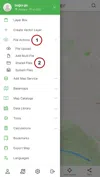
In order to display the shared files, the Sharing Files button in the File Actions in the menu is clicked.

Adding Shared File To The Map And Stop Sharing

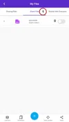
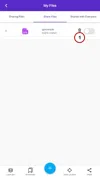
In the opened panel, the Shared Files tab is clicked. Shared files are listed here. Features such as who shared, file type, etc. appear in this list.

1. Adding Shared File to the Map

Adding Shared File To The Map And Stop Sharing

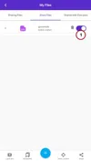
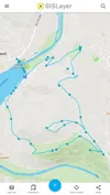
Next to each share file, there are buttons for deletion and add to map. Sharing can be easily added to the map using the Add to Map button.

Adding Shared File To The Map And Stop Sharing

2. Stop Sharing

Adding Shared File To The Map And Stop Sharing

Next to each share file, there are buttons for deletion and add to map. Sharing can be easily stopped using the Delete button.

Related Documents

Other Documents

Creating Vector Layer
Spatial Data Uploading
Upload Multiple Spatial Files
Layer Box Usage

4-Layer Box Usage

10.03.2020
Attribute Table and Features
Feature Attribute Table - Operations
Attribute Table - Text Queries And Spatial Queries
Drawing New Feature
Downloading Layer
Labels

10-Labels

10.03.2020
Z-index Replacement
Adding WFS Service
Adding WMS Service
Adding WMTS Service
Adding WFS-T Service
Adding XYZ Services
Adding PBF Service
Add Vector Tile

18-Add Vector Tile

10.03.2020
Adding Street Basemap
Adding Satellite Basemap
Adding Special Basemaps
Add Catalog

22-Add Catalog

10.03.2020
Create A Catalog File
List Catalogs

24-List Catalogs

10.03.2020
Re-Adding Previously Added Layers
Filtering With Overpass API
Creating Elevation Profile
Coordinate Tracking
Navigation

29-Navigation

10.03.2020
Application

30-Application

10.03.2020
Length Measurement
Area Measurement
Coordinate Conversion
Point Creation Using Slope And Distance
Bearing And Length Calculation
Bookmarks

36-Bookmarks

10.03.2020
Printing Out The Map
Changing The Language
Night Mode

39-Night Mode

10.03.2020
Changing Basemap
Creating Point By Clicking The Map
Height Measurement
Saving System File
Listing System Files And Adding To Map
Sharing System File
Displaying Shared Files And People
Adding Sharing File To The Map And Stop Sharing
Adding Shared File To The Map And Stop Sharing
Add, Edit, Delete Geometry in Real-Time
Sending Back System Layers Changes
Displaying Log Table
Listing Maps Shared With Everyone
Displaying Available GISMoney
Sign In

54-Sign In

10.03.2020
System Settings

55-System Settings

10.03.2020