Height measurement can be made on the map in BlueGIS software. The heights collected can be listed and displayed on the map.

Admin 10.03.2020 Category : BlueGIS Mobile Education Documents

Height measurement can be performed on the map in BlueGIS. For measuring the height, click on the 'Measurement Tools' from the quick menu (+ sign) at the bottom of the screen.

Height Measurement

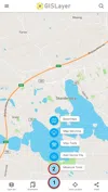
Select 'Measure the Height ' option in the panel that drop-down.
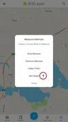
Height Measurement

1. Measuring Height

When the 'measure the height' button is pressed, you can start selecting points. The points to be measured are selected on the map.

Height Measurement

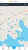
The height of the last point selected appears at the top of the screen. View all selected points with the "List" button.

Height Measurement

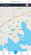
View all height points selected via this button.

Height Measurement

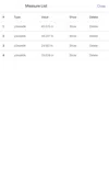
The points can be displayed on the map or deleted from the list via the "Show" and "Delete" buttons.

Related Documents

Other Documents

Creating Vector Layer
Spatial Data Uploading
Upload Multiple Spatial Files
Layer Box Usage

4-Layer Box Usage

10.03.2020
Attribute Table and Features
Feature Attribute Table - Operations
Attribute Table - Text Queries And Spatial Queries
Drawing New Feature
Downloading Layer
Labels

10-Labels

10.03.2020
Z-index Replacement
Adding WFS Service
Adding WMS Service
Adding WMTS Service
Adding WFS-T Service
Adding XYZ Services
Adding PBF Service
Add Vector Tile

18-Add Vector Tile

10.03.2020
Adding Street Basemap
Adding Satellite Basemap
Adding Special Basemaps
Add Catalog

22-Add Catalog

10.03.2020
Create A Catalog File
List Catalogs

24-List Catalogs

10.03.2020
Re-Adding Previously Added Layers
Filtering With Overpass API
Creating Elevation Profile
Coordinate Tracking
Navigation

29-Navigation

10.03.2020
Application

30-Application

10.03.2020
Length Measurement
Area Measurement
Coordinate Conversion
Point Creation Using Slope And Distance
Bearing And Length Calculation
Bookmarks

36-Bookmarks

10.03.2020
Printing Out The Map
Changing The Language
Night Mode

39-Night Mode

10.03.2020
Changing Basemap
Creating Point By Clicking The Map
Height Measurement
Saving System File
Listing System Files And Adding To Map
Sharing System File
Displaying Shared Files And People
Adding Sharing File To The Map And Stop Sharing
Adding Shared File To The Map And Stop Sharing
Add, Edit, Delete Geometry in Real-Time
Sending Back System Layers Changes
Displaying Log Table
Listing Maps Shared With Everyone
Displaying Available GISMoney
Sign In

54-Sign In

10.03.2020
System Settings

55-System Settings

10.03.2020