Options such as length unit, area unit, application language to be used in the application can be changed from the system settings.

Admin 10.03.2020 Category : BlueGIS Mobile Education Documents

In BlueGIS application, unit settings and language options used in the application can be changed from the System Settings menu. To access the System Settings menu, click the Settings button in the left menu.
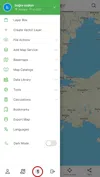
Sign In

1. Settings

Sign In

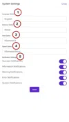
There are different settings in the system settings menu. Changeable settings:

  1. Language Options

  2. Length Measurement Unit

    . Meter

    . Mile

    . Degree

    . Radian

  3. Area Measurement Unit

    . Meter^2

    . Kilometer^2

  4. Speed Measurement Unit

    . Kilometer/hour(km/h)

    . Meter/second (m/s)

  5. Notification Settings

    . Confirmation Notifications

    . Information Notifications

    . Alert Notifications

    . Error Notifications

    . System Notifications

The changed settings are valid in all panels within the application. Do not forget this when changing settings.

Sign In

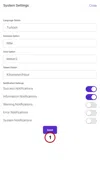
To save the settings, click on the Save button under the panel.

Related Documents

Other Documents

Creating Vector Layer
Spatial Data Uploading
Upload Multiple Spatial Files
Layer Box Usage

4-Layer Box Usage

10.03.2020
Attribute Table and Features
Feature Attribute Table - Operations
Attribute Table - Text Queries And Spatial Queries
Drawing New Feature
Downloading Layer
Labels

10-Labels

10.03.2020
Z-index Replacement
Adding WFS Service
Adding WMS Service
Adding WMTS Service
Adding WFS-T Service
Adding XYZ Services
Adding PBF Service
Add Vector Tile

18-Add Vector Tile

10.03.2020
Adding Street Basemap
Adding Satellite Basemap
Adding Special Basemaps
Add Catalog

22-Add Catalog

10.03.2020
Create A Catalog File
List Catalogs

24-List Catalogs

10.03.2020
Re-Adding Previously Added Layers
Filtering With Overpass API
Creating Elevation Profile
Coordinate Tracking
Navigation

29-Navigation

10.03.2020
Application

30-Application

10.03.2020
Length Measurement
Area Measurement
Coordinate Conversion
Point Creation Using Slope And Distance
Bearing And Length Calculation
Bookmarks

36-Bookmarks

10.03.2020
Printing Out The Map
Changing The Language
Night Mode

39-Night Mode

10.03.2020
Changing Basemap
Creating Point By Clicking The Map
Height Measurement
Saving System File
Listing System Files And Adding To Map
Sharing System File
Displaying Shared Files And People
Adding Sharing File To The Map And Stop Sharing
Adding Shared File To The Map And Stop Sharing
Add, Edit, Delete Geometry in Real-Time
Sending Back System Layers Changes
Displaying Log Table
Listing Maps Shared With Everyone
Displaying Available GISMoney
Sign In

54-Sign In

10.03.2020
System Settings

55-System Settings

10.03.2020