Changes made within the system layers can be sent back to the system and the changes can be recorded.

Admin 10.03.2020 Category : BlueGIS Mobile Education Documents

Geometric and non-geometric changes made in system files are not saved in the system at the same time. The changes made must be sent back to the system to be saved in the system. Same rules exist for personal files for sharing files.

1. Adding System File to the Map

Sending Back System Layers Changes

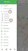
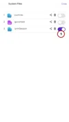
In order to upload the system file to the map, click on the button named My Files in the System in the File Actions menu.

Sending Back System Layers Changes

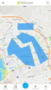
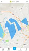
The layer desired to be worked on is loaded on the map.

Sending Back System Layers Changes

2. Making Changes on Layer

Various changes can be made within the layer. Like adding geometry, editing geometry, deleting geometry or changing the geometry feature. Various geometries have been added, deleted or edited within the sample.

Sending Back System Layers Changes

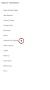
In order to send the changes back to the system, the layer box opens and the options of the layer to be sent back are opened. Click on 'Send Back to System' option in the options.

Sending Back System Layers Changes

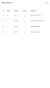
In the opened panel, all the changes (Adding, editing, deleting geometry) within the layer are listed. You can manage the changes made within the layer as you wish. If you want, the changes are restored and the changes are sent to the system and the file in the system is updated.

You can send geometries one by one to the system or easily send collectively. Likewise, you can undo the changes made in the geometries one by one or cancel all the changes by undoing them collectively.

Sending Back System Layers Changes

A status message will greet you after clicking this option. This way you can be sure the geometries are sent correctly.

Sending Back System Layers Changes

Related Documents

Other Documents

Creating Vector Layer
Spatial Data Uploading
Upload Multiple Spatial Files
Layer Box Usage

4-Layer Box Usage

10.03.2020
Attribute Table and Features
Feature Attribute Table - Operations
Attribute Table - Text Queries And Spatial Queries
Drawing New Feature
Downloading Layer
Labels

10-Labels

10.03.2020
Z-index Replacement
Adding WFS Service
Adding WMS Service
Adding WMTS Service
Adding WFS-T Service
Adding XYZ Services
Adding PBF Service
Add Vector Tile

18-Add Vector Tile

10.03.2020
Adding Street Basemap
Adding Satellite Basemap
Adding Special Basemaps
Add Catalog

22-Add Catalog

10.03.2020
Create A Catalog File
List Catalogs

24-List Catalogs

10.03.2020
Re-Adding Previously Added Layers
Filtering With Overpass API
Creating Elevation Profile
Coordinate Tracking
Navigation

29-Navigation

10.03.2020
Application

30-Application

10.03.2020
Length Measurement
Area Measurement
Coordinate Conversion
Point Creation Using Slope And Distance
Bearing And Length Calculation
Bookmarks

36-Bookmarks

10.03.2020
Printing Out The Map
Changing The Language
Night Mode

39-Night Mode

10.03.2020
Changing Basemap
Creating Point By Clicking The Map
Height Measurement
Saving System File
Listing System Files And Adding To Map
Sharing System File
Displaying Shared Files And People
Adding Sharing File To The Map And Stop Sharing
Adding Shared File To The Map And Stop Sharing
Add, Edit, Delete Geometry in Real-Time
Sending Back System Layers Changes
Displaying Log Table
Listing Maps Shared With Everyone
Displaying Available GISMoney
Sign In

54-Sign In

10.03.2020
System Settings

55-System Settings

10.03.2020