Shared files can be easily added to the map. In addition, sharing can be stopped again after sharing.

Admin 10.03.2020 Category : BlueGIS Mobile Education Documents

In BlueGIS software, you can display the files you have shared, add them to the map and stop sharing.

1. Adding Sharing File to the Map

Adding Sharing File To The Map And Stop Sharing

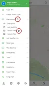
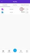
To display the files you have shared, the Sharing Files button in the File Actions menu is clicked.

Adding Sharing File To The Map And Stop Sharing

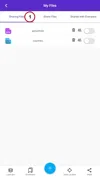
The My Shared Files tab is clicked on the opened panel. Share files are listed here. There are button groups next to each share file.

Adding Sharing File To The Map And Stop Sharing

The file can be easily added to the map by activating the button on the far right.

Adding Sharing File To The Map And Stop Sharing

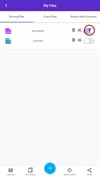
2. Collectively Stopping Sharing Files

Adding Sharing File To The Map And Stop Sharing

You can collectively remove the sharing of actions you have shared. You can do this with the trash button in the file list you shared.

Adding Sharing File To The Map And Stop Sharing

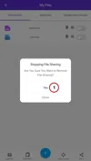
Sharing can be easily removed by clicking Yes to the question of Are you sure you want to stop this sharing.

Note: Shares with all users are removed in this method.

3. Stopping Person Based Sharing

Adding Sharing File To The Map And Stop Sharing

It is possible to stop sharing collectively as well as to stop sharing based on person. When the Users button in the Sharing Files List is clicked, the shared users are listed.

Adding Sharing File To The Map And Stop Sharing

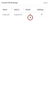
With the Delete button on the far right of the users, user-based sharing stop action is taken.

Related Documents

Other Documents

Creating Vector Layer
Spatial Data Uploading
Upload Multiple Spatial Files
Layer Box Usage

4-Layer Box Usage

10.03.2020
Attribute Table and Features
Feature Attribute Table - Operations
Attribute Table - Text Queries And Spatial Queries
Drawing New Feature
Downloading Layer
Labels

10-Labels

10.03.2020
Z-index Replacement
Adding WFS Service
Adding WMS Service
Adding WMTS Service
Adding WFS-T Service
Adding XYZ Services
Adding PBF Service
Add Vector Tile

18-Add Vector Tile

10.03.2020
Adding Street Basemap
Adding Satellite Basemap
Adding Special Basemaps
Add Catalog

22-Add Catalog

10.03.2020
Create A Catalog File
List Catalogs

24-List Catalogs

10.03.2020
Re-Adding Previously Added Layers
Filtering With Overpass API
Creating Elevation Profile
Coordinate Tracking
Navigation

29-Navigation

10.03.2020
Application

30-Application

10.03.2020
Length Measurement
Area Measurement
Coordinate Conversion
Point Creation Using Slope And Distance
Bearing And Length Calculation
Bookmarks

36-Bookmarks

10.03.2020
Printing Out The Map
Changing The Language
Night Mode

39-Night Mode

10.03.2020
Changing Basemap
Creating Point By Clicking The Map
Height Measurement
Saving System File
Listing System Files And Adding To Map
Sharing System File
Displaying Shared Files And People
Adding Sharing File To The Map And Stop Sharing
Adding Shared File To The Map And Stop Sharing
Add, Edit, Delete Geometry in Real-Time
Sending Back System Layers Changes
Displaying Log Table
Listing Maps Shared With Everyone
Displaying Available GISMoney
Sign In

54-Sign In

10.03.2020
System Settings

55-System Settings

10.03.2020