You can increase the efficiency of your work by sharing the system files you have saved in the system with other users. You can also do your work on a common file.

Admin 10.03.2020 Category : BlueGIS Mobile Education Documents

You can share the files you have saved in the system with other users. You can authorize the users you share and make collaborative work much more efficient.

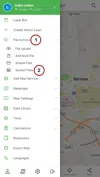
You can share files from the System Files list. To view the system files, click the "My Files on the System" button from the File Actions section in the menu.

Sharing System File

1. File Sharing

Sharing System File

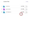
The files saved in the system are listed in the System Files list. There is a group of buttons next to each save. There is a Share button in the button groups. The Share button next to the file to be shared is clicked.

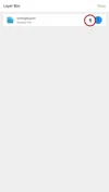
Another way to reach the Sharing Panel is if the system layer to be shared is loaded on the map, it can be accessed from the Layer Box options.

Sharing System File

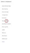
Click on the Share option from the options panel that opens.

Sharing System File

2. File Sharing Panel

Sharing System File

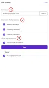
File sharing panel includes User Search Box and Authorization Settings.

  1. User Search Box

  2. Geometric Authorizations

    a. Geometry Add Authorization

    b. Geometry Edit Authorization

    c. Geometry Deletion Authorization

  3. Other Authorizations

    a. Download Authorization

Sharing System File

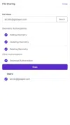
The file can be shared with multiple users at the same time. Sharing is completed with the Share button after user selection and authorization settings are made.

Related Documents

Other Documents

Creating Vector Layer
Spatial Data Uploading
Upload Multiple Spatial Files
Layer Box Usage

4-Layer Box Usage

10.03.2020
Attribute Table and Features
Feature Attribute Table - Operations
Attribute Table - Text Queries And Spatial Queries
Drawing New Feature
Downloading Layer
Labels

10-Labels

10.03.2020
Z-index Replacement
Adding WFS Service
Adding WMS Service
Adding WMTS Service
Adding WFS-T Service
Adding XYZ Services
Adding PBF Service
Add Vector Tile

18-Add Vector Tile

10.03.2020
Adding Street Basemap
Adding Satellite Basemap
Adding Special Basemaps
Add Catalog

22-Add Catalog

10.03.2020
Create A Catalog File
List Catalogs

24-List Catalogs

10.03.2020
Re-Adding Previously Added Layers
Filtering With Overpass API
Creating Elevation Profile
Coordinate Tracking
Navigation

29-Navigation

10.03.2020
Application

30-Application

10.03.2020
Length Measurement
Area Measurement
Coordinate Conversion
Point Creation Using Slope And Distance
Bearing And Length Calculation
Bookmarks

36-Bookmarks

10.03.2020
Printing Out The Map
Changing The Language
Night Mode

39-Night Mode

10.03.2020
Changing Basemap
Creating Point By Clicking The Map
Height Measurement
Saving System File
Listing System Files And Adding To Map
Sharing System File
Displaying Shared Files And People
Adding Sharing File To The Map And Stop Sharing
Adding Shared File To The Map And Stop Sharing
Add, Edit, Delete Geometry in Real-Time
Sending Back System Layers Changes
Displaying Log Table
Listing Maps Shared With Everyone
Displaying Available GISMoney
Sign In

54-Sign In

10.03.2020
System Settings

55-System Settings

10.03.2020