You can view the files you have saved to the system in BlueGIS software and add them to the map easily

Admin 10.03.2020 Category : BlueGIS Mobile Education Documents

You can view your files saved in BlueGIS software and continue your work by adding them to the map as you wish. The style of the layers added to the map is loaded back into the map as it is saved in the system. In addition, if the system is loaded into the layer with labels from the loads, the labels will be loaded again automatically.

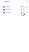
1. Listing System Files

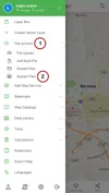
In order to view the system files, the "My Files in the System" button is clicked under "File Operations" in the menu.

Listing System Files And Adding To Map

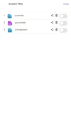
In the opened panel, your files saved in the system are listed. You can see the saved file type with the photo icon. Files are saved in the system with their layer names and are listed.

Listing System Files And Adding To Map

2. Adding System Files to Map

Sistem Dosyalarını Listeleme Ve Haritaya Ekleme

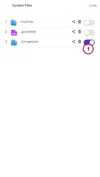
There is a button group for each file in the System Files list. The desired file can be easily added to the map with the slider button on the far right of the button group.

Listing System Files And Adding To Map

If the button is turned off again, the layer will be deleted from the map. You can also manage your layer through your files.

3. Deleting Files from System

Listing System Files And Adding To Map

File can be saved to the system and can be easily deleted. There is a button in the form of a trash can within the button group next to each layer in the system file list.

Listing System Files And Adding To Map

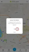
When you press this button next to the file you want to delete, a question appears that you are sure you want to delete the file. If you answer Yes the file will be deleted from the system.

Related Documents

Other Documents

Creating Vector Layer
Spatial Data Uploading
Upload Multiple Spatial Files
Layer Box Usage

4-Layer Box Usage

10.03.2020
Attribute Table and Features
Feature Attribute Table - Operations
Attribute Table - Text Queries And Spatial Queries
Drawing New Feature
Downloading Layer
Labels

10-Labels

10.03.2020
Z-index Replacement
Adding WFS Service
Adding WMS Service
Adding WMTS Service
Adding WFS-T Service
Adding XYZ Services
Adding PBF Service
Add Vector Tile

18-Add Vector Tile

10.03.2020
Adding Street Basemap
Adding Satellite Basemap
Adding Special Basemaps
Add Catalog

22-Add Catalog

10.03.2020
Create A Catalog File
List Catalogs

24-List Catalogs

10.03.2020
Re-Adding Previously Added Layers
Filtering With Overpass API
Creating Elevation Profile
Coordinate Tracking
Navigation

29-Navigation

10.03.2020
Application

30-Application

10.03.2020
Length Measurement
Area Measurement
Coordinate Conversion
Point Creation Using Slope And Distance
Bearing And Length Calculation
Bookmarks

36-Bookmarks

10.03.2020
Printing Out The Map
Changing The Language
Night Mode

39-Night Mode

10.03.2020
Changing Basemap
Creating Point By Clicking The Map
Height Measurement
Saving System File
Listing System Files And Adding To Map
Sharing System File
Displaying Shared Files And People
Adding Sharing File To The Map And Stop Sharing
Adding Shared File To The Map And Stop Sharing
Add, Edit, Delete Geometry in Real-Time
Sending Back System Layers Changes
Displaying Log Table
Listing Maps Shared With Everyone
Displaying Available GISMoney
Sign In

54-Sign In

10.03.2020
System Settings

55-System Settings

10.03.2020