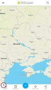
In BlueGIS software, the layers you add to the map are listed in the layer box. It also allows some actions to be taken on these layers.
Layer box can be accessed from the "Layer Box" button in the left menu.
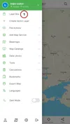
In addition, the layer box can be accessed easily with the "Layer Box" option from the buttons under the screen.
Step 1: Layer Box Features
Layers can be easily processed in the Layer Box.
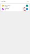
When the button next to the layer you want to process is clicked, some options will appear.
These Features:
1.1. The Menu of Layers Not Saved to the System:
When the created layers are not saved in the system, different features appear in the layer box options.

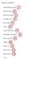
- Open Attribute Table: Open the attribute table of the layer.
- Make New Drawing: Allows new drawing on the vector layer.
- Show on Map: Allows the map to zoom in on this layer.
- Change Color: Allows to change the color of the vector layer.
- Download: Allows the download of the vector layer.
- Save to System: Allows the layer to be saved to the system.
- Labels: Labels can be added to the layer.
- Move Up: Moves the z-index value of the layer up.
- Move Down: Moves the z-index value of the layer down.
- Delete Layer: Allows the layer to be deleted from the map.
1.2. The Menu of Saved Layers to the System:
When the created layers are saved to the system, there are features that appear in the layer box options. These;
- Open Attribute Table: Opens the attribute table of the layer.
- Make New Drawing: Allows new drawing on the vector layer.
- Show on Map: Allows the map to zoom in on this layer.
- Change Color: Allows to change the color of the vector layer.
- Download: Allows the download of the vector layer.
- Share: Allows the layer to be shared.
- Layer Chat Panel: Allows you to communicate with your group friends in group work.
- Send Back to System: Sends the changes made in the layer back to the system. It saves the changes made.
- View Log File: Changes made in system files are saved in log file. When the changes are made and by whom can be seen with log files.
- Labels: Labels can be added to the layer.
- Move Up: Moves the z-index value of the layer up.
- Move Down: Moves the z-index value of the layer down.
- Delete Layer: Allows the layer to be deleted from the map.


Related Documents