There are many coordinate systems. Sometimes it may be necessary to convert between coordinate systems. BlueGIS software can also perform these conversions.
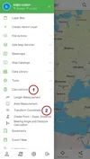
Coordinate Transformation panel can be accessed from the 'Coordinate Transformation' option under the 'Calculations' in the left menu.
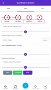
There are 3 main menus in the coordinate transformation panel.
1. Map: Used for displaying the map
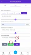
2. Point: Coordinate transformation operations are performed on this menu
3. List: Coordinate transformation results are listed here
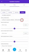
1. Step: Point Selection
First, select the point in the coordinate transformation panel. There are different methods for selecting the point.
1. Location: The user's location is taken
2. From the map: Point is selected from the map
3. Search: Searching for the place with search panel
4. Typing: Enter Coordinate manually
Point selection is performed by one of these four methods.
1.1. Location
In this option, the user's location is taken. As a coordinate system, EPSG: 4326 (WGS84) is used.
1.2. From the map
Select the point from the map. As a coordinate system, EPSG: 4326 (WGS84) is used.
1.3. Search
Search the place with the search panel. As a coordinate system, EPSG: 4326 (WGS84) is used.
1.4. Typing
Coordinate is entered manually. Users can determine the coordinate system.
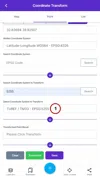
2. Step: Determining the Coordinate System to Convert
After the point selection is made, select which coordinate system the point will be transformed to. There are 3 coordinate systems at the beginning:
-
EPSG-4326 (WGS 84)
-
EPSG-4917 (ITRF96)
-
EPSG-3857
If another coordinate system other than these will be used, it can be easily found from the search panel.
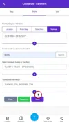
3. Step: Transformation Result
Press the convert button at the end of the panel to complete the coordinate transformation. The result will appear on the screen.
4. Step: Saving the Point
The converted point can be saved. Press the save button to save.
After pressing the "Save" button, a panel drop-downs then enter the record name.
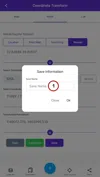
At this stage, the saving process is completed.
5. Step: Viewing Previous Saves
The transformation results saved in the list, which is one of the three main menus in the coordinate transformation, are listed.
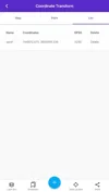
Saves can be deleted with the "Delete" button. To view the point on the map, just click on the coordinates.


Related Documents