Area measurement can be made on the map in BlueGIS software. Area measurement is explained in this document.

Admin 10.03.2020 Category : BlueGIS Mobile Education Documents

Area measurement can be done on the map in BlueGIS software. Area measurement can be accessed in two ways.

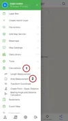
The first way to activate the area measurement is the left menu under the 'Calculations' with the 'Area Measurement' option.

Area Measurement

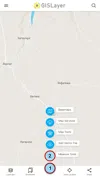
The second way is to select the 'Area Measurement' option from the 'measurement tools' in the quick menu (+ button) at the bottom of the screen.
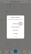
Area Measurement

Area Measurement

1. Area Measurement

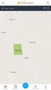
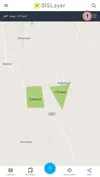
After clicking the area measurement option, drawing a polygon can be started directly on the map. After finishing to draw, the result will appear at the top of the screen.

Area Measurement

Measurement of multiple areas is possible on the Map. The measurements are listed on the table with their results. The table can be accessed with the first button next to the measurement result.

Area Measurement

Note: The last measurement you take is displayed at the top of the screen.

Note: The unit of measurement selected in the settings is used.

All measurements and results are displayed on the table.

Area Measurement

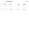
The drawing can be displayed on the map with the "Show" button next to the measurements. You can delete the measurements from the map and the table with the "Delete" button.

Related Documents

Other Documents

Creating Vector Layer
Spatial Data Uploading
Upload Multiple Spatial Files
Layer Box Usage

4-Layer Box Usage

10.03.2020
Attribute Table and Features
Feature Attribute Table - Operations
Attribute Table - Text Queries And Spatial Queries
Drawing New Feature
Downloading Layer
Labels

10-Labels

10.03.2020
Z-index Replacement
Adding WFS Service
Adding WMS Service
Adding WMTS Service
Adding WFS-T Service
Adding XYZ Services
Adding PBF Service
Add Vector Tile

18-Add Vector Tile

10.03.2020
Adding Street Basemap
Adding Satellite Basemap
Adding Special Basemaps
Add Catalog

22-Add Catalog

10.03.2020
Create A Catalog File
List Catalogs

24-List Catalogs

10.03.2020
Re-Adding Previously Added Layers
Filtering With Overpass API
Creating Elevation Profile
Coordinate Tracking
Navigation

29-Navigation

10.03.2020
Application

30-Application

10.03.2020
Length Measurement
Area Measurement
Coordinate Conversion
Point Creation Using Slope And Distance
Bearing And Length Calculation
Bookmarks

36-Bookmarks

10.03.2020
Printing Out The Map
Changing The Language
Night Mode

39-Night Mode

10.03.2020
Changing Basemap
Creating Point By Clicking The Map
Height Measurement
Saving System File
Listing System Files And Adding To Map
Sharing System File
Displaying Shared Files And People
Adding Sharing File To The Map And Stop Sharing
Adding Shared File To The Map And Stop Sharing
Add, Edit, Delete Geometry in Real-Time
Sending Back System Layers Changes
Displaying Log Table
Listing Maps Shared With Everyone
Displaying Available GISMoney
Sign In

54-Sign In

10.03.2020
System Settings

55-System Settings

10.03.2020