The coordinates of the user can be recorded in the BlueGIS mobile application. It can then be used for various analysis.

Admin 10.03.2020 Category : BlueGIS Mobile Education Documents

Coordinates of the user can be tracked in BlueGIS and various analyzes can be done later. Coordinate tracking panel can be accessed via the 'Coordinate Tracking' option from the 'Tools' menu.

Coordinate Tracking

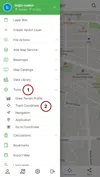
Step 1: Coordinate Tracking

When coordinate tracking is run for the first time, the user's location is displayed on the map and coordinate recording is started.

Coordinate Tracking

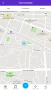
There are 3 main menus on the coordinate tracking panel.

  1. Map: The map appears

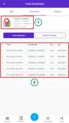
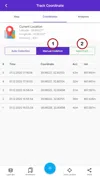
  2. Coordinates: Collected coordinates can be seen in this menu

  3. Analyzes: Various analyzes are shown

2. Coordinates Menu

Coordinate Tracking

  1. Current Location

  2. Collected coordinate list

Again, there are two possibilities. In addition to automatic adding, you can also add the coordinates manually. For manual addition, the Save button should be clicked.

Coordinate Tracking

3. Analysis Menu

Coordinate Tracking

Coordinate Tracking

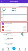
In the analysis menu,

  1. Elevation Profile: Elevation profile during coordinate tracking

  2. Buttons:

    a. Download as GPX: The collected data is downloaded as a GPX file

    b. Show Points: Collected points are displayed on the map

    c. Show Line: On the map, the coordinated line is displayed

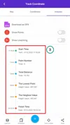
  3. Coordinate Tracking Information

    a. Start time: Coordinate tracking start time

    b. Number of Dots: Number of created points.

    c. Total Length: Total path length (meters)

    d. Lowest Point: The lowest height along the way

    e. Highest Point: Highest height along the way

    f. End time: Coordinate tracking end time

Analysis is available

Related Documents

Other Documents

Creating Vector Layer
Spatial Data Uploading
Upload Multiple Spatial Files
Layer Box Usage

4-Layer Box Usage

10.03.2020
Attribute Table and Features
Feature Attribute Table - Operations
Attribute Table - Text Queries And Spatial Queries
Drawing New Feature
Downloading Layer
Labels

10-Labels

10.03.2020
Z-index Replacement
Adding WFS Service
Adding WMS Service
Adding WMTS Service
Adding WFS-T Service
Adding XYZ Services
Adding PBF Service
Add Vector Tile

18-Add Vector Tile

10.03.2020
Adding Street Basemap
Adding Satellite Basemap
Adding Special Basemaps
Add Catalog

22-Add Catalog

10.03.2020
Create A Catalog File
List Catalogs

24-List Catalogs

10.03.2020
Re-Adding Previously Added Layers
Filtering With Overpass API
Creating Elevation Profile
Coordinate Tracking
Navigation

29-Navigation

10.03.2020
Application

30-Application

10.03.2020
Length Measurement
Area Measurement
Coordinate Conversion
Point Creation Using Slope And Distance
Bearing And Length Calculation
Bookmarks

36-Bookmarks

10.03.2020
Printing Out The Map
Changing The Language
Night Mode

39-Night Mode

10.03.2020
Changing Basemap
Creating Point By Clicking The Map
Height Measurement
Saving System File
Listing System Files And Adding To Map
Sharing System File
Displaying Shared Files And People
Adding Sharing File To The Map And Stop Sharing
Adding Shared File To The Map And Stop Sharing
Add, Edit, Delete Geometry in Real-Time
Sending Back System Layers Changes
Displaying Log Table
Listing Maps Shared With Everyone
Displaying Available GISMoney
Sign In

54-Sign In

10.03.2020
System Settings

55-System Settings

10.03.2020