The z-index value determines the order of the layers. In BlueGIS software, you can easily change this order as you wish. To change the z-index value of any layer, use the "Move Down" or "Move Up" buttons from the options of the layer that is desired to be changed in the layer box.
<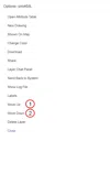
Step 1: Z-index
1.1. Move Down
<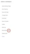
If the data of your two layers overlap, you can move the top layer below the other layer with the move down button. The first and final versions of the layers are shown below.
In the first picture, the blue layer is above the red layer. Using the "Move Down" button from the settings of the blue layer, the z-index value remains below the red layer.
<
As seen in the second picture, the blue layer is located under the red layer.
1.2. Move up
<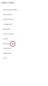
If the data of your two layers overlap, the bottom layer can be moved above the other layer with the 'move layer up' button. The first and final versions of the layers are shown below.
In the first picture, the red layer is located under the blue layer. To move the red layer over the blue layer, click the move up button of the red layer in the layer box.
<
As can be seen, the red layer was moved above the blue layer. It's that easy to change z-index values in BlueGIS.
<


Related Documents