The WFS-T service sends a change (added geometry, deleted geometry, and edited geometry) back to the source data, ensuring that the same change is present in the database. The WFS-T service can be published in the BlueGIS software.
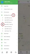
It is easy to add a WFS-T service. There are two ways to access the WFS-T add panel. The first way is the 'Add WFS-T Service' option under the 'Add Map Service' in the left menu.
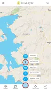
The second way is the 'Add WFS-T Service' option in the 'Map Services' menu in the quick menu (+ sign) at the bottom of the screen.
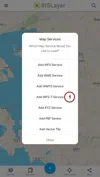
1. 'Add WFS Service' Panel
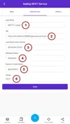
Parameters to be entered when adding WFS-T service:
-
Layer Name: Layer name that will appear in the layer box
-
URL: URL of WFS-T service
-
Layer Name Used in the Service: Layer name used in WFS-T service
-
Workspace Name: Workspace name of WFS-T service
-
Geometry Column Name: Geometry column
-
Version: Version of the service used
You must fill the parameters other than the geometry. The geometry column name will be 'geometry' if it is left blank.
Parameters used in the example:
-
Layer Name Used in Service: İzmir
-
Workspace Name: deneme
-
Geometry Column Name: geometry
-
Version: 1.0.0
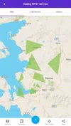
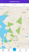
WMTS service is added to the map with the Save button. The result is shown below.
Step 2: Send a Change with WFS-T
With the WFS-T service, changes made in layers added to the map (added geometry, deleted geometry, edited geometry) can be sent to the server. If a change is made in the layer (added, deleted, or edited editing geometry), the changes are sent to the service again.
Here, for example, new geometry with a new drawing is added to the layer.
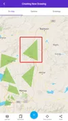
It is quite simple to send this added geometry back to the used service. Layers added with the WFS-T feature in the layer box have an additional option called 'send changes'.
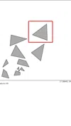
Clicking this option, all changes made in the layer are sent to the service side. You can see the changes made in the service.
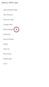
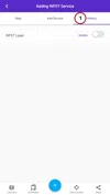
3. WFS-T Service history
There are 3 main menus in the adding WFS-T service panel. There is a 'History' button under the third main menu. In this menu, WFS-T layers added to the map are saved. Thus, a WFS-T layer that is desired to be added before can be easily added to the map without having to re-enter the parameters on the map.
The layer we added in the first step is now displayed in history. It is enough to scroll the box to add it back to the map. If desired, easily remove the layer from the history with the "Delete" button.
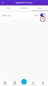
When you activate the button, the WFS-T layer is automatically added to the map again.


Related Documents