Labels can be added to vector layers in BlueGIS software. To add a label, click the labels button in the layer box.
<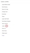
Step 1: Adding Tags
<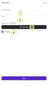
There are some options in the adding tags panel.
-
Tag Column: Select which column you will take the tag from.
-
Size: Change the size of the tag.
-
Label Color: Change the color of the label as you wish.
-
Visibility: Set the visibility of the tags.
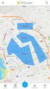
After making the selections, click the Save button. Tags appear at the selected settings above the geometries. The sample tagging result is shown below.
<


Related Documents