If there are common geometries used or important places to be recorded on the map, it is very easy to do this in BlueGIS software.

Admin 10.03.2020 Category : BlueGIS Mobile Education Documents

If frequently used geometries or important locations are to be shown on the map, this can be easily implemented in the BlueGIS software.

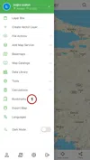
There are two ways to access the bookmarks panel. The first method via the 'Bookmarks' in the left menu.

Bookmarks

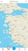
The second way is to click on the 'Bookmarks' from the buttons at the bottom of the screen.

Bookmarks

1. Step: Add Geometries to Bookmarks

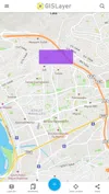
The geometries available on the map can be added to Bookmarks. As an example, some geometries have been added to the map.

Bookmarks

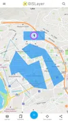
To add these geometries to the bookmarks, click on it. A panel drop-downs on the right. Here, the information of the clicked geometry is displayed.

Bookmarks

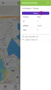
A panel will drop-down after clicking the settings button. Click on the 'Add to bookmarks’ option in this panel.

Bookmarks

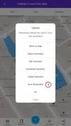
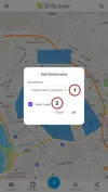
Then, it is necessary to enter a name for this record. It initially comes under the name ' bookmarks Places'. This name can be changed optionally.

With the automatic loading option at the bottom of the panel, it can be determined whether the geometry will be visible on the map when the application is first launched. In other words, the user can have the geometries shown on the map when the map is first loaded.

Bookmarks

Now, when the map is first loaded, the geometry will automatically open on the map.

Bookmarks

2. Step: Listing Bookmarks Geometries

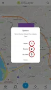
The saved geometries are listed in the bookmarks panel.

Bookmarks

You can add to the bookmark on the map with the Add bookmark Place button. The options button is available next to each geometry. With this button, there are options to show the geometry on the map, to delete the geometry, and to navigate with navigation.

Bookmarks

Related Documents

Other Documents

Creating Vector Layer
Spatial Data Uploading
Upload Multiple Spatial Files
Layer Box Usage

4-Layer Box Usage

10.03.2020
Attribute Table and Features
Feature Attribute Table - Operations
Attribute Table - Text Queries And Spatial Queries
Drawing New Feature
Downloading Layer
Labels

10-Labels

10.03.2020
Z-index Replacement
Adding WFS Service
Adding WMS Service
Adding WMTS Service
Adding WFS-T Service
Adding XYZ Services
Adding PBF Service
Add Vector Tile

18-Add Vector Tile

10.03.2020
Adding Street Basemap
Adding Satellite Basemap
Adding Special Basemaps
Add Catalog

22-Add Catalog

10.03.2020
Create A Catalog File
List Catalogs

24-List Catalogs

10.03.2020
Re-Adding Previously Added Layers
Filtering With Overpass API
Creating Elevation Profile
Coordinate Tracking
Navigation

29-Navigation

10.03.2020
Application

30-Application

10.03.2020
Length Measurement
Area Measurement
Coordinate Conversion
Point Creation Using Slope And Distance
Bearing And Length Calculation
Bookmarks

36-Bookmarks

10.03.2020
Printing Out The Map
Changing The Language
Night Mode

39-Night Mode

10.03.2020
Changing Basemap
Creating Point By Clicking The Map
Height Measurement
Saving System File
Listing System Files And Adding To Map
Sharing System File
Displaying Shared Files And People
Adding Sharing File To The Map And Stop Sharing
Adding Shared File To The Map And Stop Sharing
Add, Edit, Delete Geometry in Real-Time
Sending Back System Layers Changes
Displaying Log Table
Listing Maps Shared With Everyone
Displaying Available GISMoney
Sign In

54-Sign In

10.03.2020
System Settings

55-System Settings

10.03.2020