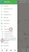
In BlueGIS software, you can calculate the bearing angle and length between two points.
To calculate the bearing and length, use the "Bearing and Length Calculation" option under the "Calculations" on the left menu.
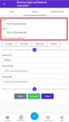
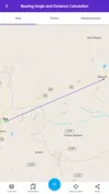
There are 3 main menus in the neighborhood and length calculation panel.
1. Map: Used for displaying the map
2. Points: Bearing and length calculations
3. Measurements: Saved measurements are listed here
1. Step: Point Selection
Select two points. Then, determine the selection method. There are different methods for selecting the point.
1. Location: The user's location is taken
2. From the map: Point is selected from the map
3. Search: Searching for the place with search panel
4. Typing: Enter Coordinate manually
Point selection is performed by one of these four methods.
1.1. Location
In this option, the user's location is taken. As coordinate system, EPSG: 4326 (WGS84) is used.
1.2. From the map
Select the point with point drawing on the map. As coordinate system, EPSG: 4326 (WGS84) is used.
1.3. Search
Search the place with the search panel. As coordinate system, EPSG: 4326 (WGS84) is used.
1.4. Typing
Coordinate is entered manually. As coordinate system, EPSG: 4326 (WGS84) is used.
2. Step: Bearing and Length Calculation
Once the points are selected, the unit of measurement should be selected. Units that can be used:
-
Metre
-
Kilometer
-
Mile
-
Degree
-
Rad
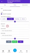
After selecting the points, the neighborhood angle and distance between the two points are calculated and displayed on the screen.

3. Step: Saving Results
Calculated results can be saved. After entering the name, click the "Save" button.
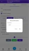
At this stage, the saving process is completed.
4. Step: Viewing Previous Saves
Saved results are listed in the list menu, which is one of the three main menus in the bearing and length calculation.

Here, you can access length and bearing angles of the records. Records can be deleted with the "Delete" button. To view the records on the map, simply click on the save name.


Related Documents